Berhida
Berhida
Berhida municipality lies on the boundary of the north-eastern Balaton-highlands and northern Mezőföld, South of the foothills of the Bakony, in the valley of the Séd brook between the M7 motorway and Route 8, 13 km from lake Balaton.
History
The Romans knew the settlement and called it Cimbrianae.
From among the kings of the house of Árpád, Géza II visited the place several times.
Development of the village grew rapidly after the foundation of the Ipari Robbanóanyaggyár (Industrial Explosives Factory) in 1923. Its legal successor is the Peremartoni Vegyipari Vállalat (Peremarton Chemical Industrial Company). Some 70% of the population make a living from industry.
Following the change in regime the factory was liquidated and 15 new enterprises were formed.
Architectural relics
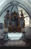
The medieval roman catholic church is on the main street of the village. The baroque church on the main square was built 1772-78 in the place of the old church.
Culture, sport
The Community Centre was opened in 1964. Numerous sports facilities are available: 2 football pitches, 2 training grounds, 2 tennis courts, a running track, a basketball and 2 handball pitches as well as a conditioning room.
Events
Traditional Winter farewell, harvest procession, grape harvest procession. Parish-feasts are held twice a year. The Berhidai Napok (Berhida Days) series of events is organized in September.
 Subregion
 MENU
MENU